The biggest UK cities
A few data analytics ideas from
Data-to-Viz.com

This document gives a few suggestions to analyse a dataset composed
by a set of geographic coordinates that have an associated numeric
value.
It considers the population of 925 cities in the UK. This
example dataset is provided in the R maps library and is
available on this Github
repository. Basically it looks like the table beside.
# Libraries
library(tidyverse)
library(hrbrthemes)
library(kableExtra)
options(knitr.table.format = "html")
library(viridis)

# Load dataset from github
data <- read.table("https://raw.githubusercontent.com/holtzy/data_to_viz/master/Example_dataset/18_ListGPSCoordinatesWithValue.csv", header=T)

# show data
data %>% head(5) %>% kable() %>%
kable_styling(bootstrap_options = "striped", full_width = F)| lat | long | pop | name |
|---|---|---|---|
| 51.65 | -3.14 | 10146 | Abercarn-Newbridge |
| 51.72 | -3.46 | 33048 | Aberdare |
| 57.15 | -2.10 | 184031 | Aberdeen |
| 51.83 | -3.02 | 14251 | Abergavenny |
| 53.28 | -3.58 | 17819 | Abergele |
The go-to graphic in this kind of situation is probably the bubble map. Basically, one circle is drawn per provided geographic position. The size of the bubble is proportional to its corresponding numeric value. Warning, remember that the bubble area must be proportional to the value, not its radius.
# Get the world polygon and extract UK
library(maps)
UK <- map_data("world") %>% filter(region=="UK")

# Easy to make it interactive!
library(plotly)

# plot
p=data %>%

  arrange(desc(pop)) %>%
  mutate( name=factor(name, unique(name))) %>%
  mutate( mytext=paste("City: ", name, "\n", "Population: ", pop, sep="")) %>%  # This prepare the text displayed on hover.

  # Makte the static plot calling this text:
  ggplot() +
    ggplot2::annotate("text", x = 1, y = 56.3, label="1000 biggest cities in the UK", colour = "black", size=4, alpha=1) +
    ggplot2::annotate("segment", x = -1, xend = 3, y = 56, yend = 56, colour = "black", size=0.2, alpha=1) +
    geom_polygon(data = UK, aes(x=long, y = lat, group = group), fill="grey", alpha=0.3) +
    geom_point(aes(x=long, y=lat, size=pop, color=pop, text=mytext, alpha=pop) ) +
    scale_size_continuous(range=c(0.3,12)) +
    scale_color_viridis(option="inferno", trans="log" ) +
    scale_alpha_continuous(trans="log") +
    theme_void() +
    ylim(50,59) +
    coord_map() +
    theme(
      legend.position = "none"
    )

p <- ggplotly(p, tooltip="text")Note: this map is interactive. Hover a bubble
to get the city name and its population, Zoom on a specific part for
more details.
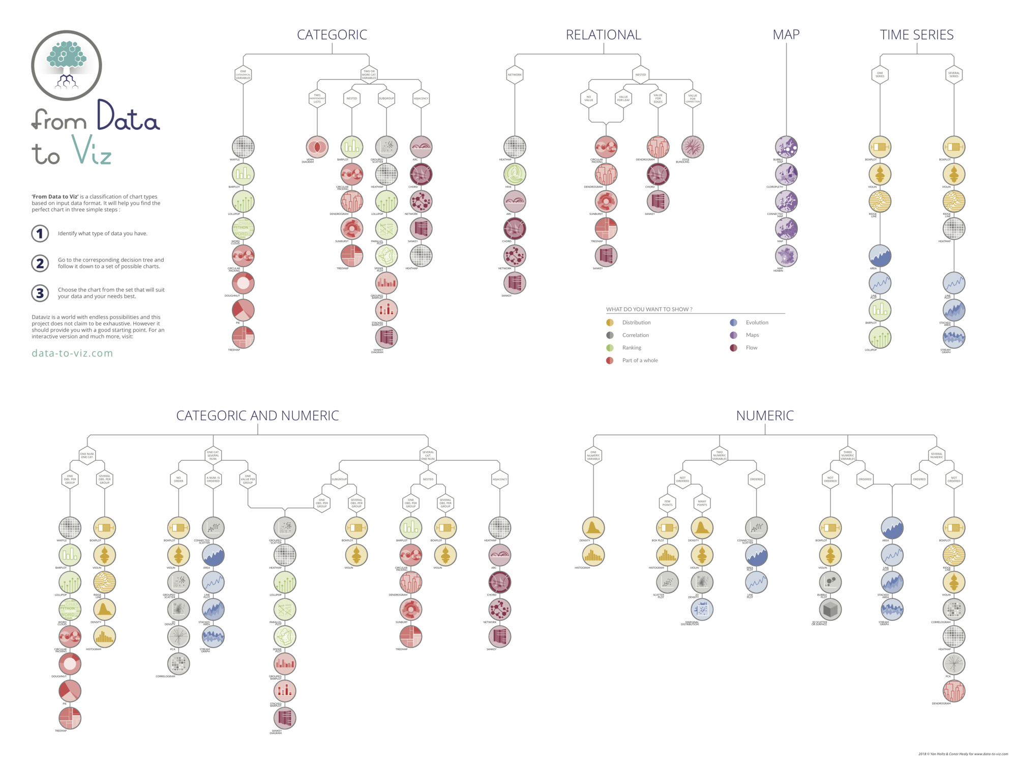
You can learn more about each type of graphic presented in this story in the dedicated sections. Click the icon below:
Data To Viz is a comprehensive classification of chart types organized by data input format. Get a high-resolution version of our decision tree delivered to your inbox now!
A work by Yan Holtz for data-to-viz.com